 According to long time anglers, there is a big difference between ‘fishing’ and ‘catching’. Fishing refers to the attempt to have one of our Piscean friends grab on to your bait; catching is the act of having said fish available for photo opportunities or as the evening entree. The area near Drumheller offers at least four distinct possibilities for those of you looking for great ‘fishing’ opportunities within a one hour drive. Two of those spots are located within Starland County and are operated and maintained by contracted employees. The McLaren Dam Recreational area offers users potable water, communal kitchens and well defined campsites.
Located approximately 80 kilometers north and east of Drumheller near the intersection of Secondary Highways 589 and 851, the McLaren Dam’s location is marked by signage leading to it’s exact location at Township Road 33-4 and Range Road 18-2. Stocked with trout since the mid-1970’s, McLaren Dam has a reputation for some sizeable trout being taken (up to 16 inches by some reports) and has gained a strong following of local anglers. The second opportunity to catch the elusive ‘Badlands Trout’, is offered at the Michichi Recreational site located within Michichi’s corporate limits. Although the water’s surface area is smaller than the McLaren site, Michichi has benefited from the from the fish stocking program of the provincial government for well over 25 years.
The campground and day use facilities at Michichi are all in great shape and drinking water and washroom facilities are well maintained. Michichi’s smaller size allows for more shore access with a lesser amount of walking required to find your own fishing spot. The recreation area that contains the reservoir is located approximately 20 kilometres from downtown Drumheller, just north of the intersection of Township Road 30-4 and Range Road 19-0. When travelling on Highway 9 north of Drumheller, the intersection of Twp Rd. 30-4 is hard to miss because of the railroad crossing bearing the title ‘Dinosaur Junction’ just metres east of the highway. Just a few kilometres east on 30-4 and a left turn at Range Rd. 19-0 and Michichi’s trout await. A third lake that produces some big fish is the Crawling Valley Reservoir located south of Drumheller approximately 70 kilometres. To get there travel east from Drumheller to Rosedale and turn south on Highway 56, just passed the Hussar turnoff is an intersection with Secondary Highway 561, head east approximately 18 kilometres and look for the signs. Crawling Valley Reservoir is on the south side of the highway. The lake has a good variety of fish, and fishermen often return to Drumheller boasting of the size of the fish they catch. Walleye in the lake are big but regulations state they are catch and release only, as the stocks are being replenished. Last but not least of the Badlands offerings is the Red Deer River.
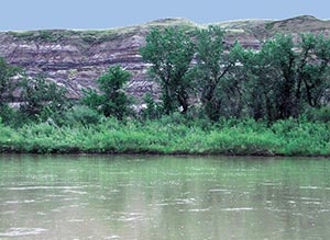
Drumheller is located in what is referred to as Reach 4 of the Red Deer River’s Integrated Management Plan. In the Plan, Reach 4 is described as “ a warm water fishery as
indicated by the absence of trout species. All sport fish species are
native and include walleye, sauger, pike, goldeye and mooneye.” Avid anglers know the Red Deer River can produce some trophy size fish. There are a number of easily accessible riverbank fishing spots from
within the designated town parks and some old timers in the area might
point you to some other prime locations. To quote a common bumper sticker, “A bad day of fishing is a lot better than a great day at work.”


